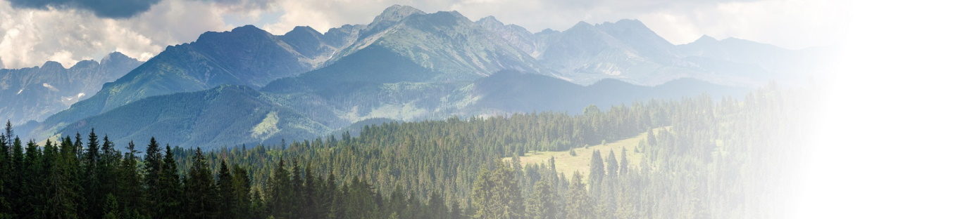
2016 Triple ascent of Mont Ventoux
- Wheelygood Rating: Hard
- Length: 134km
- Height Gain: 4400m
- Route: https://www.plotaroute.com/route/1118136
[Editor’s note: This was written in the aftermath of my gaining entry to the Club des Cinglés du Mont Ventoux in 2016 and is, thus, a bit rambling and also before the time of photographs. Sorry.]
And, now, the moment you’ve all been waiting for…
Wot I done on my holidays…
I’d make sure that you’ve been to the lavatory and have plenty of drinks and snacks at hand, as this one has a … few … words in it …
I’ve split despatches away from the Strava post for this one, mainly because I was far, far, too tired to type anything up last night and, in fairness, deserves its own slot this time around. As I’ve done previously, some of the usual rules have been gently discarded in favour of a fruitier approach as this wasn’t a club run.
It was the day of the triple ascent and there we were, sitting around like condemned men (and women) at an early breakfast. The only people not fazed about the day were my friend Jason (not of the Vagabonds), who’d already done it two days earlier and was back for another one, and Nathan, an American guest who was only planning to do one, or, possibly, two ascents anyway. The rest of us tried to tell our stomachs to relax and allow some more food in, rather than doing what mine was, which was slowly becoming the size of a conker.
We all rode gently away from the hotel, bright and early, but not speaking very much. The plan was to use the 12km, or so, from the hotel to Malaucène as a leg loosener/warm-up before hitting the first ascent, which seemed to work well and everyone was in cheerful mood as we turned left in Malaucène onto the bottom of the climb.
Before I go any further, it might be worth explaining how this all works. The basic idea of the challenge is the ascend, and descend, all three of the road routes that take you from the bottom to the top of Mont Ventoux. The three start points are Bédoin (this is the classic one used by the Tour de France), Malaucène and Sault. The Bédoin and Sault ascents converge 6km from the top at Chalet Reynard, so you get to do the stretch from there to the summit twice. You can do the ascents in any order you like, but you need to get them done in 24 hours: to prove it there’s a brevet card that has to be stamped at the top and bottom and you also need to log your times at the top and bottom of each ascent/descent.
The most common route is to head up from Bédoin first, then Malaucène and, finally Sault. This means that you do the climbs in descending order of difficulty. The location of our hotel, Faucon, means that we would be going in the order Malaucène, Bédoin, Sault, an order that some suggested wasn’t ideal, but, then again, none of us fancied the idea of riding around to Bédoin before we started, which would have added an extra 25km, or so, onto the day.
So, anyway, we began the first climb as a group, but it became apparent that we weren’t quick enough for Jason, who said he’d see us at the top and then rode away. The remainder of the group stuck together at the very bottom, because there’s not much by way of gradient and we were deliberately taking it easy. As soon as the road kicked up into the 6-7% range, two triads formed: Jason Ratcliffe (henceforth known as Ratty to distinguish him from the other Jason), Michael and myself, then Tania, Martin and Nathan.
The three of us took it nice and steady from the bottom until, about 1km later, when Michael decided to stretch his legs a bit and headed up the hill. That was the last Ratty and I saw of him until the top. To keep things sensible, the two of us then ‘buddied up’, which, despite the connotations, actually means that you ride line astern, swapping over the lead position every so often – for us it was every km. If the two of you are evenly matched, as we were, then it means that you can keep the pace in check and you have someone to talk to for the couple of hours that you’ll be ascending.
Let me say right now, that the Malaucène ascent is great. Yes, there’s a 4km stretch at 11%, but there are plenty of bits at a far shallower gradient than that. It probably helped that we were heading up there quite early in the morning, when the sun was just starting to warm the parts and there was almost no wind, but it felt comfortable enough and we’d managed to get into a rhythm that we were happy we could sustain for a long time. The road winds its way gently, but resolutely, through the trees and, for a good period, I couldn’t have been happier.
Along the way we passed a few other riders – a couple with some serious pannier action were the standouts. We also caught – very slowly – a local French rider and, for about 5km, we formed a train of three, which made it even better for us. He was sightly quicker on the steep stuff and marginally slower on the shallower stuff, but we adapted as best we could. Until the 11% section, where we let him go as his pace was just that bit higher than we were prepared to go. If we’d been going for a single ascent, then I’d have gone with it, but we had a long day ahead and it was worth conserving the energy.
As we popped above the treeline, we caught our first glimpse of the summit. Unlike the two other ascents, there isn’t far to go before you reach it, so we began to get quite cheerful about it all. This lasted until the last few hairpins, which all seemed to have photographers on them determined to provide us with a momento of the day. It got slightly worse in that Ratty and I had put the plastic frame things on so they knew we were going for the triple ascent and, therefore, would probably be even keener for photos.
A few minutes’ later and we’d arrived at the top and found the support van ready and waiting for us. The bottle filling and food stuffing had to wait, though, because the first order of the day was to get our brevet cards stamped. Once done, it was time to add magic carbohydrate powders and water to bottles and assorted items to mouths. Feeling replete, we applied arm warmers and gilets to our persons (take note, boys and girls – you can get very cold on Alpine descents!) and headed away towards Bédoin.
It was then that I ran into the first unpleasant surprise of the day as a gust of wind hit and the bike was pushed a little across the road. As soon as I got 100 yards further down the road, it all calmed down, but it went to show that the ‘Vent’ part of ‘Ventoux’ was well justified. It didn’t take long to realise that, despite the indicated gradients, the long descent was actually very relaxing one you got into the swing of it. It helped that Ratty was in front of me until Chalet Reynard, so I had someone of similar ability to follow and learn from. Fortunately, I didn’t learn everything, as he shot across the fork heading towards the wrong road (Sault), thus putting me on the front.
On the front again: just like a Club Run. Still, I’d had time to work out what I was prepared to accept in terms of corner entry speed and stuck to that as a rule all the way down. It wasn’t long before the other side of the road got pretty busy with cyclists, motorcyclists and cars. The best bit was that every single one of them was watching for riders, like me, coming down the hill and keeping out of the way. Apart from the two muppets who were zigzagging up the hill, oblivious to everything else around them.
It was then that I had my second unpleasant surprise of the day. I had a requirement to clear a nostril. Well, both nostrils, actually. In and of itself, that’s fine, but, just sometimes, the expulsion of material is, um, only partial, thus leaving you with a mucus situation. Normally that’s fine too, but, on this occasion I had a situation where Jason (who’s a very good descender) had caught me up and I wanted to let him pass along with oncoming cyclists riding two abreast and a car who was determined to come past no matter what. And a hairpin bend. The good new was that there was nothing here that a closed mouth and some common sense couldn’t deal with, but all was well and I got myself cleaned up on the next straight bit.
Once the ground flattened out before the town, I just let the bike roll along and was, eventually, caught by Ratty and Michael and the three of us landed in Bédoin together. Card stamping and water bottle time, along with a visit to the WC, which was becoming an issue for me as there aren’t any at the top. I was followed there by Michael … um, no, that sounds even more wrong than I thought it was. What I meant was that there was a mutual need of the facil … sigh … look, we both needed the bog, OK?
Cards stamped, somewhat lighter and one short (Nathan had decided to ride around the mountain, rather than over it to get back to the hotel), we set away again, back up the road we’d just ridden down. Less than 100 yards later, we were joined by a British lad who asked if he could tag along for a bit, which was fine. It didn’t last that long as he was demonstrably quicker than most of us, so I just let him, and Michael go up the road – after we’d heard the story that he might have had a cracked frame, but that the bike shop had said it was OK.
Anyway, Jason went up the road a short time later and it wasn’t long before Ratty and I were on our own again. The road up from Bédoin is definitely busier than Malaucène, although there were fewer bikes than I’d seen on the way down. The climb itself starts gently out of the village at an easy enough, but still noticeable gradient. That changes once you hit the hairpin at the bottom of the forest, where it becomes a very long pull up to Chalet Reynard.
Bugger me, the Bédoin climb’s hard. It gives you nothing back, anywhere. The word that’s used most often to describe this climb was ‘relentless’ and I can understand why, even if I don’t quite agree, if only because all the Alpine climbs that I’ve done are relentless. It goes on pretty steadily for the best part of 10km, with an average gradient of between 9 and 10%, although it does vary between about 7 to 11%, so it’s not the absolutely constant ramp that some would have you believe: it’s still possible to be careful with your energy and keep to the outside of the corners to minimise the slope, but there’s not as much to be gained by this as on some other climbs.
Is it the hardest climb I’ve ever done? Hmm. For me, I still think Hardknott at the end of the Fred Whitton Challenge is the hardest, but this is tough in a whole different way.
On my way back from the final climb, I was chatting with our guide/support artist, Andy, and he was saying that people turn up with all sorts of grand strategies in their heads for getting up Ventoux: ‘I’ll use this gear here and this gear there’, etc., but he simply tells them that all they need to remember to do is pick their lowest gear once they reach the left hand hairpin at the bottom the forest and stick with it until Chalet Reynard. Having done this, I can say that, unless you’re a pro, this is perfect advice.
Anyhow, Ratty and I settled into buddy mode once again and we began to grind our way up the slope. We passed a few people on the way up, most impressive of whom was a gentleman with a prosthetic leg who was making his way up in a quietly determined fashion and had left his, naturally bipedal, friend behind.
Not long after this came the phrase ‘this is horrendous’ from Ratty and I could feel things backing off. What I should have done at this point was back it off too, but I felt absolutely OK and decided just to carry on at the pace we’d been riding at. This worked great for about 5km, ironically about 30 seconds after Andy had driven by in the van to ask if I needed anything (‘no’ was the – wrong – reply). I had to back off the effort – about 5% was enough – and continued to ride through what now felt like a furnace. It got worse, before it got better – the tree cover began to thin out and I was convinced that this meant that I was getting close to Chalet Reynard. Unfortunately, it was just a thinning of the tree cover, in preparation for the next dense forest section. Damn. It was double damn when I discovered how much water I didn’t have left. It reached triple damn when my body said ‘Gel. Right now!’
Minor crisis averted (there’s water in SiS isotonic gels – hurrah!), I kept on ticking over and, eventually, I reached the Chalet hoping like hell that Andy would be there. No such luck and I ploughed on, hoping that he’d turn up at some point. He did and, this time, when I was asked if I needed anything, the (correct) answer was ‘water – and quickly’, which was duly made available a couple of hundred yards further up the road, although, at 8%, this takes longer to cover than you might imagine.
Bottle filled, salt tablet swallowed, Andy told me that Ratty wasn’t that far behind, so I decided to wait for him at the van. The long and short of it was that I’d made a pacing mistake and knew that, for both physical and morale reasons, the best thing we could do would be to carry on together.
Our next target was the Tommy Simpson memorial, which is further up the mountain than I thought it was: there’s not much more than 1km to go before the top. It took a couple of goes to reach it was Ratty’s legs were cramping up, but we made it and I popped down the Vagabonds cap that I’d brought along for that very purpose. A couple of photos later and there was nothing for it, but to keep on heading up to the top, passing the 507m to go marker as we went.1
Having reached the top and quickly donned our gilets, it was time to head down to Chalet Reynard. And lunch. This was important – being France, if you don’t get bums on seats by 2pm then you’re out of luck and it was about 13:40 by this time. We landed at Chalet Reynard to find Jason and Michael already there, having commandeered a table large enough for the group. Drinks were ordered and we sat down to wait for Tania and Martin.
It was just as well we were happy to wait, because we’d been beaten to it by a whole coachload of elderly sightseers, which meant that our choices were limited: crepes now, or whatever you want if you’re OK to hang on. Just a thought! We hung on, although Ratty and I did move seats in order to catch the sun and warm up just a little.
A little while later, Tania rolled into the car park and came to join us for a short period – she wasn’t stopping and had a breakfast bar, or two, and headed off down to Sault on her own. Whilst she was getting her bits in order, she told us that Martin had decided that two ascents were sufficient and that he’d headed straight back down to Malaucène from the top. The rest of us continued to wait until our omelettes and frites arrived. This proved problematic for me, as bits of my internals were starting to shut down and I had to leave half the frites for fear of seeing them again.
Ratty took the opportunity to buy himself a Ventoux gilet-cum-jacket and we were soon on our way, although Jason and Michael got a head start as Ratty had to get his GoPro set up for the descent.
The first part of the descent was fantastic – very quiet, not that much gradient and bends that allowed you to take a really smooth line through them, as will, hopefully, be shown on his footage of me, once I’d stopped waving and grinning like an utter fool.
Then I had my third unpleasant surprise, when I crashed.
You see, there was this coach being trailed by a motorbike and a couple of cars. That was fine and we both waited for our opportunity to thread our way up the line. Jason managed to get past everything, but my first opportunity was taken away by the motorhome that was coming the other way … which caused the coach and all of the following vehicles to stop in a hurry. I applied a bit much front brake at this point and was, therefore unable to prevent myself from tapping the protruding wheel of the bike being carried on the back of the Audi A3 in front and over the bars I went.
The good news is that, apart from some bruises, a couple of small friction burns, and a small scuff on the rear mech (the hangar is still straight), both I, and the bike, are absolutely OK. I think I was saved by the slickness of the gilet, which meant I slid down the road or a few inches, rather than coming to a sudden stop. There’s not even a scuff on my jersey, or shorts, both of which must have hit the ground.
Anyway, I got up straight away, checked that all the bits were working and straight, put the chain on the bike, said I was OK to the nice Dutch lady who’d got out of the car to check, waited for the traffic to start moving and got on with it. By this time, of course, Ratty had nadged off down the mountain and had absolutely no idea where I was, or what had happened.
Full of adrenaline, but a little fear, I worked my way up through the line of traffic whenever it was clear to do so. I managed to exchange a gestured conversation with the motorcyclist that, yes, I’d gone over the handlebars, but, no, I wasn’t injured. Shortly after this, there was a good, clear stretch and I managed to get past the coach and set off down the road with a vague thought that I might catch Ratty before I got to Sault, having remembered to wave at Tania, who was on her way up her final ascent. Amazingly, I did – he’d slowly freewheeled along, wondering where I was and, pretty much at the bottom of the descent just before the, unadvertised, bonus ascent into the village itself I found myself on his rear wheel and we made our way up to get the final stamp on the brevet cards.
That bonus ascent into Sault means that the final ascent of Mont Ventoux actually begins by going downhill. Ratty and I, once again, watched Jason and Michael ride away from us and concentrated on the job in hand, which was simply to keep turning the pedals a best we could to the top. It’s fair to say that we were both pretty tired by this point and, despite the fact that the Sault ascent is the easiest, we were still making hard work of it with a combination of my lack of go and Ratty’s leg cramps.
The climb up to Chalet Reynard is 20km long with an average gradient of 4.5%. What they don’t tell you is that the first 15km of this are at 5-6% and the final few at 3% or shallower, which explains why we were both getting a bit fed up during the early part of the climb.
If only it were that simple. As we reached the easier section, we heard the sound of thunder and there were a few spots of rain. Having seen a thunderstorm on the top of the mountain from the bar a few days ago, we knew what this would be like and a sense of foreboding enveloped us.
The mood was lightened somewhat at Chalet Reynard, where I had to use the facilities and was, momentarily, trapped in the toilet block by the flock of sheep that the shepherd was moving from one area to the next. Once I’d pretended to apply my Jedi Mind Trick to the sheep (or, possibly the other way around) I made it back to the bike and there was nothing for it other than to head uphill for the final 6km.
Then my real problems started. Turning the pedals felt easy enough, but after a short period, I’d start to feel like I wanted to throw up. I kept it going as best I could, but I was aware that the weather was changing for the worse. I had to stop. Several times. The weather closed down at about 4.5km to go and we were suddenly riding in a reasonable downpour: Andy arrived with the van, but we elected to keep riding to get it over and done with. Credit to Ratty, he stayed with me until the last km, where he had to carry on riding so as not to get cold and I tried to stop hyperventilating. Annoyingly, I had to stop after I’d made it past the 507m sign. Even more annoyingly, the cloud cleared for a bit and I was only 100m from the summit. Damn, damn, damn.
The van was a welcome sight and, having crashed earlier in the day I’d intended to get it it and be driven down to the bottom on the wet roads. This was scuppered when I found out that the challenge itself, strictly speaking, requires three ascents, which I had covered and the three matching descents, of which I was one short.
There was nothing for it, but to finish the Rule 5 bottle, don the wet weather gear and head off down the mountain for the last time. Credit needs to go to Michael for hanging back so that we both made it down OK. This was just as well as the road was soaking wet and I took it really easy at the top. It didn’t help that it felt really cold by this stage, to the point where we had to stop at the ski station and warm up in the sun. It was at this point that I found that the battery in my Garmin was about flat, so, in order to prevent much wailing and gnashing of teeth later on, I stopped the recording and saved the ride at that point.
Onwards, and downwards, we went. The conditions were improving – slowly. We passed sections of what looked like snow by the side of the road (we found out later that it was hail, because Tania had been caught in it and, then, taken shelter in a kind French couple’s car until things calmed down again) and other section where the water was evaporating from the road surface, which reduced visibility to tens of yards and the temperature by about six degrees.
All of a sudden, the roads began to get drier and the temperature rose noticeably and I began to relax on what had been, to that point, the most horrendous descent I’ve ever made. The conditions continued to improve all the way down and, by the last 10km, or so, the roads were completely dry, the sun was out and the wind was non-existent and I could relax properly all the way down into Malaucène. Michael, who’d been hanging back for me, gently pulled away as I made my way down at a pace that I was comfortable with and I reached the bottom a minute, or so, after he did to find him with the rest of the group who were sitting in a cafe with assorted beers and hot drinks.
I settled down, ordered a hot chocolate and began to shake quite seriously from the cold. Despite this, I managed to avoid the embarrassment of spilling a hot drink over myself and emptied the contents into the correct orifice, after which I was much improved. I had, though decided that I was getting in the van to get back to the hotel: everyone else was riding, but most of my bits had gone on strike and my head had simply had enough. So, without regret, I waved ta-ra to Ratty, Tania and Michael (Jason having headed straight back), climbed in the van and was driven back.
I arrived to find Martin and Nathan swapping stories of the day and was parried from my intended shower, followed by curling up into a small ball by the offer of beer and the chance to describe some of my own tales of the day. Jason materialised a few minutes later and, as the second beer arrived, so did Tania, Ratty and Michael, which was just as well as it was starting to get quite dark by this stage and some time was spent disgorging our thoughts of the day amongst ourselves until it was time for dinner, followed by a mass tired stupor before heading for bed. For the record, my second beet was never drunk – I was just too tired and emotional!
And therein is the tale of the triple ascent of Mont Ventoux: my Mad Challenge for 2016. Done. Ticked off. I even have the jersey. Curling up into a tiny ball will have to wait…
So – congrats to fellow Vagabonds Tania, Ratty, Martin and Michael as well as my friend Jason. Once the paperwork goes through, we will all be fully subscribed members of the Club des Cinglés du Mont-Ventoux and, therefore, certified screwballs. Mwahahahahahaha!
And, thus, ladies and gents, dispatches finishes. The text continues, though, but there’s no more story, just some personal observations on the day and its aftermath…
The whole thing was, for me, something of a learning experience. Prior to this holiday, I’ve never ridden a bicycle abroad in any serious capacity; once, or twice as a child, but no more. I have to say that the continental roads are far better than ours at home and, in general, the acceptance of cyclists by other road users is pretty impressive. Perhaps it’s the rather more relaxed atmosphere in general that makes the difference, but it’s a very pleasant change compared to some of the situations we experience on the roads in the UK.
I learned many other things too: eating at the top of the hill is a good idea, because it allows the food to digest on the descent and you’re ready to go for the next one. Of course, that only really works when your descents are longer than 20 minutes, so trying that in the UK, probably won’t help all that much, but it’s a recommendation from the people here. I wish it had worked better for me – somewhere along the line, my innards packed up, which, I think, was one of the factors that made life difficult on the second and third ascents.
Descending mountains isn’t like I expected. Having ridden up assorted sections at 10,11 and 12% I thought is would be an utter nightmare to have to deal with them on the way down, but that just wasn’t the case. They never seemed that steep, or that scary, whilst you were riding down them and it was easy to get into a flow that allowed me to keep well within my comfort zone, but still travelling as what turned out to be a pretty decent pace. Unless it’s wet and cold – there are few words that can adequately convey how nasty that third descent was.
Heat can be a problem. We were slightly fortunate in that the day we went for it afforded us quite a bit of cloud cover, but, having felt the heat of the day up from Bédoin, the additional temperature would have made fluid intake a real issue. The flipside is that I’d probably have been more reticent to try carrying on up the hill ahead of Ratty.
And the final thing I learned was that this type of long ascent doesn’t forgive. Make a mistake with something (usually pace) at the bottom and it’s with you right the way to the top. This is magnified on a multi-col day, because you don’t get that much time, even with the decent descents, to put it right before the next one starts.
If there are any other road climbs you’d like me to take on, the more ridiculous the better, then please send me a message on my FaceBook page https://www.facebook.com/wheelygoodcycling/ or email me on wheelygoodmail@gmail.com and let me know…
The long Alpine climbs usually have small markers by the side of the road to indicate how many km there are still to climb and also the average percentage gradient for that next km. The final marker up from Chalet Reynard on the Ventoux is, in true French style, at 507m to go, presumably just to rub it in that the final section of the climb has an average gradient of 11% ↩


Hi, there are a number of ways to set up your own blog. The quickest and easiest is probably to sign up directly with WordPress and use their free facility. It looks pretty painless to do, but the downside is that you’re signing up to all of the content being ‘owned’ by WordPress. Also, they control the advertising you see. I’m lucky in that I personally know a local Internet Service Provider who put together a server for me (there are plenty of others around – a quick Google turned up a bunch, for example https://www.123-reg.co.uk/web-hosting/wordpress/ ) and sorted out things like my domain name so that all I had to do was log in to the new machine, set up the way the site looked and began adding content. Yes, there’s a occasional bit of housekeeping to do, but it’s not much and it means I’m in control of the site – content, advertising and all… Hope this helps…