Egton High Moor – Simon Warren #150
- SW Rating: 8/10
- Wheelygood Rating: Medium
- Length: 4.18 miles
- Avg. gradient: 4%
- Category: 3
- Strava Segment: https://www.strava.com/segments/16677726
- Parking: There’s free parking in Egton Bridge, which is about ¾ a mile from the bottom of the climb itself.
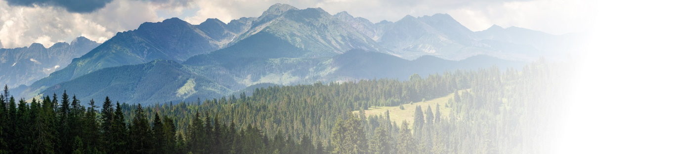
Beginning, as so few things do, with a small ford, the climb up onto Egton High Moor is a spectacular demonstration of the beauty of the North York Moors.
It’s another classic of things beginning innocuously, getting a bit nuts and then dragging on for an eternity towards the top. The very first part of the ‘climb’ is a gentle meander along the side of a river for a couple of hundred metres. And then the fun starts. As soon as the road peels away from the riverbank, the gradient pops up into the low teens for a decent length ramp, relents to almost flat then blasts back up again to about 16% before relenting once more.
Are you finished? Nope. In fact you’re now just about to come on to the steepest section of the entire climb. This starts off in the mid-teens, hops quickly into the upper teens and maintains this all the way past the first cottages on the left and around the two hairpins. Than it gets steeper – 25% in fact – until you get to the right hand curve, at which point you can relax a bit as the very steep part is now over. You even get a flat portion for, ooh, about 100m.
Then it starts to go up again. Fortunately, it’s now in ramps and which just go up to ‘quite steep’ i.e. in the teens. It doesn’t ever really give you much chance to relax and recover for the next couple of miles, although there are some sections down around 4-5% and feels pretty flat when you get there! You’ll probably also start to notice that the temperature starts to change: you’re just starting to gain enough height that it gets that degree, or two, cooler. This section feels, frankly, endless with ramp, after ramp after ramp. Just keep ticking along until you see the small forested area on the right hand side as this represents something a change of scenery.
As you pass the trees, you can see the road stretching straight out in front of you. So what’s changed? Have a closer look: the surroundings have changed from green farmland into that heathery brown of moorland. Don’t think you’re anywhere near the top, or that the crest of the road ahead is anywhere near the top, either (you’re only about half way), but you should know that the bulk of the height has now been gained. Unfortunately, if the wind is in the wrong direction, you’re now in for a miserable top section as it’s very exposed from this point. Brace yersel’, hinney!
Down the, erm, ‘down’ and over the cattle grid we go … onto the next ramp. It’s about 5%, despite what the on-screen data says1 and will sap the very will from your bones. It’s one of those classics where the top just doesn’t seem to get any closer. If it weren’t for the fact that this is an open, public, singletrack road, I’d suggest just keeping your head down and pedalling until it gets easier, but that’d be dangerous and irresponsible. So, boys and girls, keep up the steady pedalling at an effort within yourself, but don’t worry too much about the horizon. It will take care of itself! Salvation will arrive, eventually, in the form of another small wooded section on the right hand side of the road. When you reach this point, you’ve made it up that particular ramp and you can relax for a bit, because…
…there’s a descent! Yay! It’s canny, too and will make you feel glad you came up here … unless the wind is straight in your face, of course, in which case you’ll have to pedal down it and will be ruing your route choice …
This next pull is the penultimate one. It’s nothing monstrous (3-6%), but it does drag on for a bit, although nowhere near as long as the previous ramp. The only reason it’s even remotely tricky is the amount of work you’ve already had to do to get here means you’ll be that bit fatigued. Just make the most of the shallow gradients, because it’s followed by another descent and, then, a proper final ramp.
You thought this was going to end with a whimper, didn’t you? No chance. Bang it is with that 15% sting, just to let you know that it isn’t finished with you yet! It doesn’t last very long, but it does last long enough.
Once the road flattens out, you’re done. That’s it. The top of Egton High Moor. Isn’t it gorgeous up here? As you get your breath back, take in the views (and some photos) and reward yourself for a good job very well done!
If there are any other road climbs you’d like me to take on, the more ridiculous the better, then please send me a message on my FaceBook page https://www.facebook.com/wheelygoodcycling/ or email me on wheelygoodmail@gmail.com and let me know…

The windy conditions that day were playing havoc with my Garmin’s barometric altimeter. The problem is that there’s a small hole in the device case for it to get its data and when the wind is in the right direction, it pushes air into that hole and creates false readings. ↩


